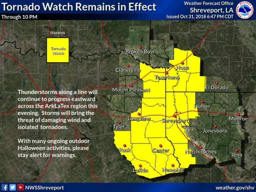
(UPDATE) Tornado Watch Expires
A tornado watch in effect for the area until 4AM Saturday morning has now been lifted. The storm system has quickly moved off to the east.
Earlier tornado watch and damage reports;
The National Weather Service has issued the tornado watch for the following regions:
In Northwest Louisiana:
Caddo, Bossier, Webster, Bienville, Claiborne, Desoto, Red River
In North Central Louisiana:
Jackson, Lincoln, Union and Winn
In Northeast Texas:
Cherokee, Gregg, Harrison, Marion, Nacogdoches, Panola, Rusk, Shelby, Smith, Titus, Upshur, Wood
In Arkansas:
Union, Columbia, Lafayette
Here are the highlights of today's severe weather thus far:
- Tornado reports: 10 as of 6:30 p.m. CDT – one in Louisiana, two in Texas and seven in Kansas.
- Damaging winds: Spotty damaging winds have been reported in parts of Texas and southern Louisiana.
- Highest Reported Wind Gusts: 80 mph in Fort Worth and Stephenville, Texas, and near Russell and Paradise, Kansas.
- Largest hail: Baseball-size hail (2.75 inches in diameter) was reported in Breaux Bridge and Catahoula in south-central Louisiana around 3:30 p.m. CDT, as well as in rural Coke County, Texas, at 3:15 p.m.
More From News Radio 710 KEEL


![Severe Storms Cause Damage in Parts of the Arklatex [VIDEO]](http://townsquare.media/site/180/files/2016/02/170529752.jpg?w=980&q=75)