Hurricane Dorian Strengthens to Cat 5 Storm
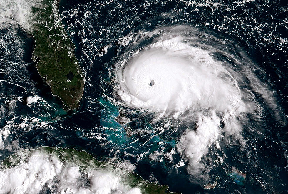
An already dangerous Hurricane Dorian intensified yet again Sunday as it closed in on the northern Bahamas, threatening to batter islands with Category 5-strength winds, pounding waves and torrential rain as people hunkered down in schools, churches and other shelters.
The National Hurricane Center in Miami said Dorian's maximum sustained winds have increased to 175 mph (280 kph), up from 160 mph (260 kph). It is moving west at 8 mph (13 kph). "Devastating hurricane conditions" are expected in The Abaco Islands early Sunday and across Grand Bahama later in the day, the center said.
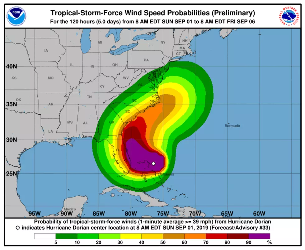
A coastal Florida county is ordering an evacuation of barrier islands, mobile homes and areas that are prone to flood because of Hurricane Dorian. Palm Beach County issued the evacuation order beginning 1 p.m. Sunday. The official forecast curves the storm away before it strikes land in the area, But the National Hurricane Center says there are variables that could alter that path and give a 50% chance of hurricane force winds in West Palm Beach by early Wednesday.
9:45 a.m.
Potentially devastating winds from Hurricane Dorian have strengthened yet again as the storm nears the Bahamas.
The National Hurricane Center in Miami said Sunday that maximum sustained winds have increased to 175 mph (280 kph) from 160 mph (260 kph) as it approaches Great Abaco Island. It is moving west at 8 mph (13 kph).
The center said at 9:30 a.m. EDT that the Category 5 storm is 25 miles (40 kilometers) east-northeast of Great Abaco Island and about 210 miles (340 kilometers) east of West Palm Beach, Florida.
The Hurricane Center is warning of potentially devastating wind gusts of more than 200 mph (321 kph) and destructive waves of up to 20 feet (6 meters).
"These hazards will cause extreme destruction in the affected areas," the center said, "and will continue for several hours."
8:55 a.m.
Weather forecasters say predictions that powerful Hurricane Dorian will slow to a crawl over the Bahamas complicates their outlook for the United States.
The National Hurricane Center says Dorian could nearly stall over Great Abaco Island or Grand Bahama Island for more than 24 hours starting late Sunday.
Hurricane Center Director Ken Graham says that would be catastrophic for the island chain. Dorian was upgraded to the most powerful designation of Category 5, with maximum sustained winds increasing to 160 mph (260 kph). Forecasters say ocean levels could rise up to 20 feet (6 meters) in parts of the northern Bahamas with the storm surge topped with huge waves.
Graham says the storm stalling also complicates the U.S. forecast. The time allows small changes in the winds that steer the storm, which means Dorian can still make landfall anywhere from Florida to North Carolina during the next five days.
___
8 a.m.
Weather forecasters say Hurricane Dorian has intensified to a Category 5 storm, capable of inflicting catastrophic levels of destruction.
The National Hurricane Center in Miami said Sunday that Dorian's maximum sustained winds have increased to 160 mph (260 kph), up from 150 mph (240 kph). It is moving west at 8 mph (13 kph)
"Devastating hurricane conditions" are expected in the Abacos Islands early Sunday, with conditions will spread across Grand Bahama Island later in the day, the center said.
In its advisory at 8 a.m. EDT, the center says the storm's center is 35 miles (55 kilometers) east of Great Abaco Island and 225 miles (360 kilometers) east of West Palm Beach.
___
5:15 a.m.
As Hurricane Dorian moves closer to the northern Bahamas, rainfall estimates have gone up for the Caribbean archipelago and the coastal Carolinas.
At around 5 a.m. Sunday, the center of the Category 4 storm was around 70 miles (110 kilometers) east of Great Abaco Island in the Bahamas and 255 miles (410 kilometers) east of West Palm Beach, Florida. The hurricane is still moving west at 8 mph (13 kph), with maximum sustained winds of 150 mph (240 kph).
A tropical storm warning was issued between Deerfield Beach up to Sebastian Inlet on southern Florida's east coast, while a tropical storm watch was issued between Deerfield Beach down to Golden Beach.
The National Hurricane Center's rainfall estimates for the northwestern Bahamas were upped to 12 to 24 inches (30 to 60 centimeters), with isolated incidents of 30 inches (76 centimeters), while estimates for the coastal Carolinas were between 5 to 10 inches (13 to 25 centimeters) of rain, with isolated cases of 15 inches (38 centimeters).
___
1:50 a.m.
Hurricane Dorian is moving ever closer to the northern Bahamas.
Early Sunday, the Category 4 storm was around 95 miles (150 kilometers) east of Great Abaco Island in the Bahamas and 280 miles (450 kilometers) east of West Palm Beach, Florida. The hurricane continues to move west at 8 mph (13 kph), with maximum sustained winds of 150 mph (240 kph).
The core of the storm is expected to be near or over parts of the northwestern Bahamas later Sunday.
Millions of U.S. coastal dwellers from Florida to the Carolinas are keeping a wary eye on Dorian's approach. Forecasters say many computer models indicate Dorian is expected to veer sharply northeastward and track up the Southeast seaboard, raising the risks of damaging winds and deadly flooding even if there's no direct U.S. landfall.
___
12 a.m.
A dangerous Hurricane Dorian is closing in on the northern Bahamas, threatening to batter the normally idyllic islands with fierce winds, pounding waves and torrential rain.
Tourist hotels closed, residents boarded up homes and officials hired boats to move people from low-lying areas to bigger islands as the powerful Category 4 hurricane approached. Many are hunkered down in schools, churches and other shelters awaiting the storm's dreaded arrival later Sunday.
Meanwhile, millions of U.S. coastal dwellers from Florida to the Carolinas are keeping a wary eye on Dorian's approach. Forecasters say many computer models indicate the storm is expected to veer sharply northeastward after passing the Bahamas and track up the Southeast seaboard, raising the risks of damaging winds and deadly flooding even if there's no direct U.S. landfall.
___
More From News Radio 710 KEEL