Massive Weather Front With Wind, Rain and Possible Hail Heading to Shreveport
The National Weather Service Forecast Office in Shreveport isn't beating around the bush on this one.
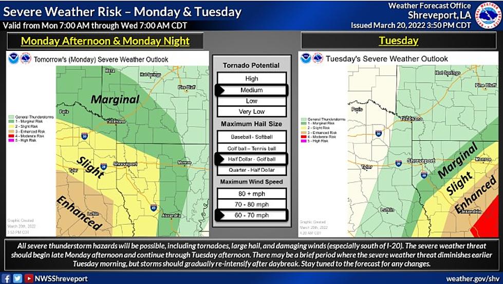
They are expecting some truly nasty weather to hit the area in the next 12 to 24 hours!
They are reporting that beginning late this (Monday, 3/21) afternoon and continuing through early tomorrow (Tuesday) afternoon, our area is at risk of tornadoes, large hail, and damaging winds, especially in the areas just south of I-20.

Most of the area including Caddo, Bossier, Webster and Desoto parishes in Northwest Louisiana and several counties in East Texas and Southern Arkansas will be under a Flood Watch from 7:00 pm tonight (Monday) until 4:00 pm tomorrow with flash flooding possible.
We Will Also Be Under A Wind Advisory
Our area will also see a Wind Advisory from 1:00 pm this afternoon which will continue to 1:00 am tonight (Tuesday) morning.
The National Weather Service is expecting Southeast winds from 15 to 20 mph with gusts up to 40 mph for portions of North Central and Northwest Louisiana, Southwest Arkansas and East and Northeast Texas.
They advise that strong winds and rough waves on area lakes will create hazardous conditions for small watercraft.
Easter Events for the Whole Family
Shreveport/Bossier's Ultimate Favorites For Fried Fish
The Top 20 Absolute Best School Districts in all of Louisiana For 2022
More From News Radio 710 KEEL


